10th Anniversary Ride on 16 May 24

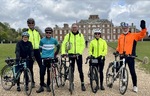
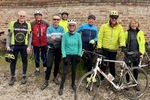
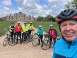
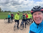
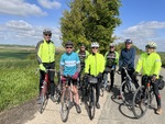
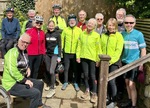
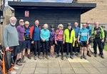
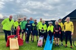
Leaders: DerekM, DerekS, John

Riders: RobW, Steve, Jim, Jean, Jo, Ian, Terry, Paul, Anne H, Simon, Mike, Philip,  Mal, Bill,
Non-Riders: Rob, Colin, Maggie, Richard, Steve

Distance: 36.8, 33.8 miles

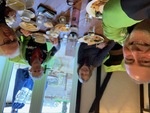
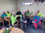
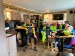
10th Anniversary Ride. Very wet, but a very good turnout, including some of the founding members.

Weather report for 2024-05-16 (between 09:00 and 17:00)
  • Wind speed 5 mph, gusting 10 mph, from the NW (varying between W and N)
  • Temperature average 14°C (12min/15max)
  • Feels like 13°C (11min/15max)
  • Sun 0.0 hours, cloud cover 100%
  • Rain 9.80 mm

Blue

(Download route as gpx file)
  • Total Distance: 36.82 miles
  • Climbing: 555.0 ft
  • Descending: -547.8 ft
  • Max elevation: 61.0
  • Min elevation: -3.6
  • Elapsed: 05:16:03
  • Moving: 02:48:42

Red

(Download route as gpx file)
  • Total Distance: 33.01 miles
  • Climbing: 518.2 ft
  • Descending: -521.5 ft
  • Max elevation: 78.7
  • Min elevation: 9.8
  • Elapsed: 13:25:53
  • Moving: 00:00:00

   
Average rating  1 2 3 4 5fYou must login to vote
image0.jpeg
image0-1.jpeg
image0.jpeg
image0-1.jpeg
image0.jpeg
image0-1.jpeg
image0.jpeg
image0-1.jpeg
image0.jpeg
image0-1.jpeg
image0.jpeg
image0-1.jpeg
image0.jpeg
image0-1.jpeg
 

240516-mg

240516-ds

Ride on 9 May 24

Leaders: Terry, Steve

Riders: Jim, Bill, Jean, Simon, Derek S, Annie, Paul, RobW, Sarah, Mike, John

Distance: 44,40 miles

Weather report for 2024-05-09 (between 09:00 and 17:00)
  • Wind speed 5 mph, gusting 12 mph, from the W (varying between SW and W)
  • Temperature average 19°C (15min/21max)
  • Feels like 19°C (15min/21max)
  • Sun 8.0 hours, cloud cover 15%
  • No rain

Green

(Download route as gpx file)
  • Total Distance: 40.25 miles
  • Climbing: 1174.2 ft
  • Descending: -1177.5 ft
  • Max elevation: 232.9
  • Min elevation: 23.0
  • Elapsed: 16:38:20
  • Moving: 00:00:00

Lightblue

(Download route as gpx file)
  • Total Distance: 44.02 miles
  • Climbing: 1433.7 ft
  • Descending: -1434.0 ft
  • Max elevation: 258.1
  • Min elevation: 14.8
  • Elapsed: 05:12:28
  • Moving: 03:18:38

Home » Ride on 9 May 24
No photos found matching your search criteria.

240509-sj 240509-mg

Snailwell on 2 May 24

Leaders: Simon, Sarah

Riders: Annie, Jo, Jean, Jim, DerekM, Terry, Mike, Rick, RobW, Ian, John

Distance: 40.3, 40.3 miles

Cool start but very warm by lunchtime

Weather report for 2024-05-02 (between 09:00 and 17:00)
  • Wind speed 7 mph, gusting 16 mph, from the SE (varying between N and W)
  • Temperature average 18°C (14min/22max)
  • Feels like 18°C (13min/22max)
  • Sun 7.8 hours, cloud cover 65%
  • Rain 0.10 mm

Black

(Download route as gpx file)
  • Total Distance: 40.38 miles
  • Climbing: 724.9 ft
  • Descending: -723.6 ft
  • Max elevation: 108.2
  • Min elevation: -5.2
  • Elapsed: 04:48:41
  • Moving: 02:40:52

Yellow

(Download route as gpx file)
  • Total Distance: 40.30 miles
  • Climbing: 1388.1 ft
  • Descending: -1383.2 ft
  • Max elevation: 355.2
  • Min elevation: 25.3
  • Elapsed: 05:18:57
  • Moving: 03:12:54

   
Average rating  1 2 3 4 5fYou must login to vote
IMG_5534.jpeg
IMG_5533.jpeg
IMG_5534.jpeg
IMG_5533.jpeg
IMG_5534.jpeg
IMG_5533.jpeg
IMG_5534.jpeg
IMG_5533.jpeg
IMG_5534.jpeg
IMG_5533.jpeg
IMG_5534.jpeg
IMG_5533.jpeg
IMG_5534.jpeg
IMG_5533.jpeg
 

240502-mg 240502-dm

Orwell on 25 Apr 24

Leaders: Terry, Anne H

Riders: DerekM, Simon, Rick, Rowland, Jim, Jean, RobW, Rhona, Derek Smith, Philip, Mike, Ian

Distance: 37.5,36.25 miles

Weather report for 2024-04-25 (between 09:00 and 17:00)
  • Wind speed 12 mph, gusting 22 mph, from the W (varying between N and NW)
  • Temperature average 10°C (8min/11max)
  • Feels like 5°C (4min/6max)
  • Sun 8.0 hours, cloud cover 70%
  • Rain 0.60 mm

Purple

(Download route as gpx file)
  • Total Distance: 37.47 miles
  • Climbing: 1534.1 ft
  • Descending: -1533.1 ft
  • Max elevation: 270.3
  • Min elevation: 43.3
  • Elapsed: 05:17:55
  • Moving: 03:11:42

Blue

(Download route as gpx file)
  • Total Distance: 36.26 miles
  • Climbing: 1020.1 ft
  • Descending: -1015.5 ft
  • Max elevation: 215.2
  • Min elevation: 32.5
  • Elapsed: 04:47:20
  • Moving: 02:57:05

   
Average rating  1 2 3 4 5fYou must login to vote
image1.jpeg
image0.jpeg
IMG_5528.jpeg
IMG_5527.jpeg
image1.jpeg
image0.jpeg
IMG_5528.jpeg
IMG_5527.jpeg
image1.jpeg
image0.jpeg
IMG_5528.jpeg
IMG_5527.jpeg
image1.jpeg
image0.jpeg
IMG_5528.jpeg
IMG_5527.jpeg
 

240425-it 240425-dm

Great Chishill on 18 Apr 24

Leaders: Steve, Derek S

Riders: Sarah, Simon, Jim, Rowland, Annie, Jo, Rhona, Anne H, Philip, Mike, Simon H, Terry, RobW, John

Distance: 34.6,38.3 miles

Weather report for 2024-04-18 (between 09:00 and 17:00)
  • Wind speed 9 mph, gusting 18 mph, from the W (varying between W and NW)
  • Temperature average 11°C (8min/12max)
  • Feels like 7°C (6min/8max)
  • Sun 5.9 hours, cloud cover 89%
  • No rain

Red

(Download route as gpx file)
  • Total Distance: 34.64 miles
  • Climbing: 1727.2 ft
  • Descending: -1767.9 ft
  • Max elevation: 373.9
  • Min elevation: -42.0
  • Elapsed: 05:35:41
  • Moving: 02:37:36

Green

(Download route as gpx file)
  • Total Distance: 38.31 miles
  • Climbing: 1270.7 ft
  • Descending: -1260.2 ft
  • Max elevation: 456.6
  • Min elevation: 32.5
  • Elapsed: 05:33:12
  • Moving: 03:09:23

   
Average rating  1 2 3 4 5fYou must login to vote
IMG_7384.jpg
image0.jpeg
image01.jpeg
IMG_7384.jpg
image0.jpeg
image01.jpeg
IMG_7384.jpg
image0.jpeg
image01.jpeg
IMG_7384.jpg
image0.jpeg
image01.jpeg
IMG_7384.jpg
image0.jpeg
image01.jpeg
 

240418-ah 240418-rt

Cottenham on 11 Apr 24

Leaders: Philip, Jim

Riders: Steve, Simon, Rowland, DerekM, Paul, John, RobW, Ian, Rhona, Annie, Sarah, Jo

Distance: 35.6,miles

An interesting ride by Jim, showing us the Roman history of Cambridge (Arbury). Maiden ride leading by Philip.

Weather report for 2024-04-11 (between 09:00 and 17:00)
  • Wind speed 12 mph, gusting 23 mph, from the W (varying between SW and W)
  • Temperature average 17°C (14min/19max)
  • Feels like 15°C (12min/17max)
  • Sun 5.4 hours, cloud cover 100%
  • Rain 0.10 mm

Lightblue

(Download route as gpx file)
  • Total Distance: 35.82 miles
  • Climbing: 1157.2 ft
  • Descending: -1108.6 ft
  • Max elevation: 135.1
  • Min elevation: -6.6
  • Elapsed: 05:24:41
  • Moving: 02:48:42

Black

(Download route as gpx file)
  • Total Distance: 39.56 miles
  • Climbing: 527.4 ft
  • Descending: -513.3 ft
  • Max elevation: 48.9
  • Min elevation: 9.5
  • Elapsed: 05:10:31
  • Moving: 03:09:51

   
Average rating  1 2 3 4 5fYou must login to vote
image1.jpeg
image1.jpeg
image1.jpeg
image1.jpeg
image1.jpeg
image1.jpeg
image1.jpeg
image1.jpeg
image1.jpeg
image1.jpeg
image1.jpeg
image1.jpeg
image1.jpeg
 

240411-pbs

240411-rt

Upware on 4 Apr 24

Leaders: DerekM, Jo

Riders: Steve, Jim, Simon, Ian, Annie, Philip, Simon H, Paul, Anne H, John

Distance: 32.8,39.7 miles

Started wet and with many puddles and flooded roads. Very muddy through Wicken Fen. But brightened up later on. Strong wind. Nice lunch at the 5 Miles Inn.

Weather report for 2024-04-04 (between 09:00 and 17:00)
  • Wind speed 14 mph, gusting 28 mph, from the SW (varying between SW and W)
  • Temperature average 14°C (11min/15max)
  • Feels like 10°C (8min/11max)
  • Sun 6.9 hours, cloud cover 73%
  • Rain 0.50 mm

Yellow

(Download route as gpx file)
  • Total Distance: 32.78 miles
  • Climbing: 512.3 ft
  • Descending: -512.0 ft
  • Max elevation: 61.0
  • Min elevation: -3.6
  • Elapsed: 05:43:45
  • Moving: 02:47:01

Purple

(Download route as gpx file)
  • Total Distance: 39.68 miles
  • Climbing: 1586.9 ft
  • Descending: -1584.9 ft
  • Max elevation: 261.1
  • Min elevation: -78.1
  • Elapsed: 05:17:11
  • Moving: 03:09:27

Home » Upware on 4 Apr 24
No photos found matching your search criteria.

240404-it 240404-ah

Great Chishill on 28 Mar 24

Leaders: Steve, Paul

Riders: Rowland, Simon, RobW, Sarah, Jim, John, Terry, Anne H

Distance: 21.7,44.6 miles

Steve’s group abandoned ride after coffee due to impending storm, but Paul’s group completed the ride!

Weather report for 2024-03-28 (between 09:00 and 17:00)
  • Wind speed 21 mph, gusting 37 mph, from the S
  • Temperature average 9°C (8min/10max)
  • Feels like 3°C (2min/4max)
  • Sun 5.6 hours, cloud cover 78%
  • Rain 4.00 mm

Blue

(Download route as gpx file)
  • Total Distance: 21.73 miles
  • Climbing: 674.7 ft
  • Descending: -686.5 ft
  • Max elevation: 260.8
  • Min elevation: 32.5
  • Elapsed: 02:28:14
  • Moving: 01:46:52

Red

(Download route as gpx file)
  • Total Distance: 44.65 miles
  • Climbing: 2593.2 ft
  • Descending: -2596.4 ft
  • Max elevation: 504.5
  • Min elevation: 61.7
  • Elapsed: 06:02:58
  • Moving: 03:39:47

   
Average rating  1 2 3 4 5fYou must login to vote
image0.jpeg
image0.jpeg
image0.jpeg
image0.jpeg
image0.jpeg
image0.jpeg
image0.jpeg
image0.jpeg
image0.jpeg
image0.jpeg
image0.jpeg
image0.jpeg
image0.jpeg
 

240328-rt

240328-ah

Balsham on 21 Mar 24

Leaders: Simon, Sarah

Riders: Rowland, Jim, John, Jean, Derek S, Annie, Alan, RobW, Rob, DerekM, Philip I, Bill, Anne H

Distance: 35.6,41.6 miles

Weather report for 2024-03-21 (between 09:00 and 17:00)
  • Wind speed 10 mph, gusting 20 mph, from the SW
  • Temperature average 12°C (8min/14max)
  • Feels like 9°C (6min/11max)
  • Sun 0.0 hours, cloud cover 92%
  • No rain

Green

(Download route as gpx file)
  • Total Distance: 41.75 miles
  • Climbing: 1294.6 ft
  • Descending: -1294.6 ft
  • Max elevation: 378.5
  • Min elevation: 15.7
  • Elapsed: 05:34:47
  • Moving: 03:27:59

Lightblue

(Download route as gpx file)
  • Total Distance: 35.66 miles
  • Climbing: 1791.5 ft
  • Descending: -1773.8 ft
  • Max elevation: 363.4
  • Min elevation: -11.2
  • Elapsed: 05:07:37
  • Moving: 02:42:24

   
Average rating  1 2 3 4 5fYou must login to vote
image0-2.jpeg
image0-2.jpeg
image0-2.jpeg
image0-2.jpeg
image0-2.jpeg
image0-2.jpeg
image0-2.jpeg
image0-2.jpeg
image0-2.jpeg
image0-2.jpeg
image0-2.jpeg
image0-2.jpeg
image0-2.jpeg
 

240321-rt 240321-ah

Steeple Bumpstead on 14 Mar 24

Leaders: Derek S, Mike G

Riders: Rhona, Rowland, Simon, Jim, Jo, Simon H, Rob, Philip, DerekM, Sarah, Annie, Jean, John, Terry, Ian T, RobWilkinson

Distance: 46,42 miles

Weather report for 2024-03-14 (between 09:00 and 17:00)
  • Wind speed 15 mph, gusting 29 mph, from the S (varying between S and SW)
  • Temperature average 14°C (10min/16max)
  • Feels like 10°C (7min/12max)
  • Sun 3.8 hours, cloud cover 66%
  • No rain

Black

(Download route as gpx file)
  • Total Distance: 46.15 miles
  • Climbing: 1924.4 ft
  • Descending: -1924.4 ft
  • Max elevation: 407.0
  • Min elevation: 14.8
  • Elapsed: 06:26:17
  • Moving: 03:40:38

Yellow

(Download route as gpx file)
  • Total Distance: 42.01 miles
  • Climbing: 1766.9 ft
  • Descending: -1767.3 ft
  • Max elevation: 416.9
  • Min elevation: 51.8
  • Elapsed: 05:55:25
  • Moving: 03:30:00

   
Average rating  1 2 3 4 5fYou must login to vote
IMG_5422.jpeg
image0.jpeg
IMG_5422.jpeg
image0.jpeg
IMG_5422.jpeg
image0.jpeg
IMG_5422.jpeg
image0.jpeg
IMG_5422.jpeg
image0.jpeg
IMG_5422.jpeg
image0.jpeg
IMG_5422.jpeg
image0.jpeg
 

240314-mg 240314-dm